With this text on devices to slow down, spread, retain runoff and facilitate infiltration of rainwater into the soil, I open a series of articles devoted to traditional methods of collecting and managing rainwater. In Latin America and Africa in particular, the rediscovery and restoration of ancestral water and soil management systems and techniques can restore the fertility of moribund lands. Knowing the ancient hydraulic systems that continue or not to be used is extraordinarily instructive because in their diversity they have explored a wide range of possible responses to the problem of water management in both arid and moisture saturated environments.
Screening dams
To slow down runoff, spread it out and facilitate infiltration of rainwater into the soil and thus contribute to soil and nutrient conservation by reducing water erosion, and by forming bands of fertile soil, a traditional type of device common on most continents consists of building filter barriers across slopes in the form of earthen dams, stone barriers and/or vegetated bands that follow the contour lines.
The oldest traces of these techniques were located in the great loess plains of northern China. These practices were also developed in India, Nepal, the Middle East, the Mediterranean rim; in Africa they are found in the Sahel in Sierra Leone, Kenya, Rwanda; they were common on the Altiplano in South America; they are still in use in Papua New Guinea...

- Murets de pierres sur les contreforts de la vallée de la Baliem en Papouasie-Occidentale
Depending on local practices and topography, these filtering obstacles are placed in continuous or discontinuous lines, usually following the contour lines. Their function is not to retain runoff, but to slow it down to mitigate its erosive power and to spread it out in a sheet.
With such patterns, the land is not terraced, although natural terraces may gradually form behind the dikes due to the movement of soil from the upper to the lower part of the bed between two lines of obstacles.
The cultivated areas are organized according to the guidance and spreading of the water induced by the filtering dams. Depending on the steepness of the slopes, the filtering dams are associated with different cultivation techniques:
The cultivated areas are organized according to the water guidance and water spreading induced by the filtering dams. Depending on the steepness of the slopes, the dams are associated with different cultivation techniques:
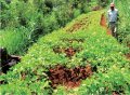
![]() On very low slopes, the cultivation areas alternate rows of weeds or bare soil serving as impluvium and rows of cultivated plants where strips of wetter soil richer in sediment and organic matter are formed;
On very low slopes, the cultivation areas alternate rows of weeds or bare soil serving as impluvium and rows of cultivated plants where strips of wetter soil richer in sediment and organic matter are formed;
![]() On steeper slopes, tiered cultivation combines fruit trees and grasses with the soil to create an oasis-like microclimate that condenses and retains rainfall when it occurs.
On steeper slopes, tiered cultivation combines fruit trees and grasses with the soil to create an oasis-like microclimate that condenses and retains rainfall when it occurs.
Depending on local resources, different materials are used to build the barriers.
Vegetal strips
Farmers in the Mandara Mountains of the Cameroonian highlands, and those in the Mbere in eastern Kenya use millet and sorghum stalks, which are not appreciated by livestock. These piled-up, slowly decomposing plants draw lines across the slope that slow down but allow water to pass through, retain some soil, and enrich the soil.

- Dans ce champ des monts Mandara, les éteules de mil ont été coupés à 80 cm du sol et couchées au sol comme dispositif antiérosif
The Dogon of southwestern Mali also use millet and sorghum stalks to compose vegetative strips in addition to other techniques such as that of planting pits locally called wégou and known in Burkina-Faso as zaï.

- Bandes végétales et fosses de plantation wégou
Lines and stone cordons
In some arid regions of the Sahel, farmers use stones to form runoff barriers that are arranged across slopes according to contour lines.

Stone lines become bund lines when filter dams have two or three levels of stones attached. In Niger, these juxtaposed or stacked stones in thin cords called "gandari" sometimes extend for miles. They have a function of rehabilitation of degraded lands by trapping the sand transported by the harmattan, the desert wind. Stone cordons for water retention can be found in most arid regions: around the Mediterranean (Italy, Greece, Spain, Syria), in the Sahel (Burkina Faso, Niger, Mali), in East Africa (Ethiopia, Rwanda), in the arid areas of southwestern North America...

Stone barriers are runoff control structures. Their serial arrangement breaks the velocity of the water and retains material from upstream. The contour construction prevents the concentration of water in one place. The wings act as a flow diversion to protect the base of the barrier in case of flooding. They thus promote the spreading out and good distribution of the flood on the plot. The water that flows slowly between the cobbles stays in the field longer, which promotes infiltration. The cords can be stabilized by being combined with plants.

Upstream of the stone alignments, strips of soil 2 to 5 meters wide are formed, enriched with water, organic matter, and nutrients. In the dry season, these barriers trap silt and sand carried away by wind erosion. In Africa, termites attracted by the organic matter dig galleries that improve the infiltration capacity of this zone. A quantity of grasses and shrubs then develop that strengthen these bunds.

- 1 Vegetated rocky ridge
In Burkina-Faso, the spacing of the cordons varies according to the slope. Farmers terminate the cordons with upward facing wings to prevent stored water from spilling out the ends. The length of a stone cordon depends essentially on the length of the plot to be treated. On average, three cordons are established per hectare, but there can be more. The time taken to develop a hectare is estimated at half a day when the work is done by a group of neighbors for groups, it takes two to five days for an individual.

The major constraint in the realization of this device is the availability of stone and their transport. The quantity of stones needed for the complete development of a plot of one hectare is close to 40 tons for a length of 300 m of stone cordons. Stone landscaping is only relevant and economical if the farmers collect the stones and pebbles directly from their plots. In mountainous regions, farmers collect troublesome stones and pile them up at the edge of the fields: if they are laid out on a contour, they function both as field boundaries and stone cordons. In Ethiopia and Rwanda, stone barriers can be more than a meter high. When stones or means are lacking, a strip of grass, sorghum, or directly, a live hedge and trees can be planted to achieve the same effect.

These devices are relatively easy to build and easily repairable, but their implementation requires a certain technicality which is due to the fact that the lithic cordons must follow the contour lines; if this is not the case, the water table gathers in the low points creating gullies that will evolve into gullies and drain the entire slope. Strictly following the contour lines is difficult on slopes of 1 to 3%. This results in widely varying widths of cultivated fields, which increases the volume of rock to be moved.

By smoothing the contours, waterways can be treated by reinforcing these areas with large stones, gradually leveling the field with cultivation techniques, improving the roughness of the soil surface with partitioned ridges, seeding grasses on either side of the ridge to slow runoff, or partitioning the field for two meters with earthen ridges.

Several studies have concluded that the installation of stone cordons exerts a positive influence on agricultural production. Lamachere and Serpentier (1992) reported an increase in millet yields of 20-40%, in dry years. According to François Lompo and Souleymane Ouedraogo (2015), using stone cordon techniques, yields increased from 700 kg/ha to 1000 kg/ha for sorghum and from 700 to 1130 kg/ha for millet. The researchers found that crops respond differently to this type of management. For example subjected to stone cordon techniques in 1995/96, white sorghum experienced a 109% yield increase, red sorghum 364% and millet 83%.
Low walls
On steep slopes, the stone strings become small low walls with various profiles. The simplest are only made up of a pile of more or less flat stones. The filtering dikes, installed in continuous lines, generally have a wide base, formed with large stones, and a narrow top made of smaller stones. The whole forms a filter.

The height of the low walls varies according to the configuration of the land and local practices. They sometimes consist of a core of fine stones covered with larger stones that protect them. Runoff water and eroded soil are partially retained upstream, the excess water flows through the stones and floods the land downstream without washing away the low wall. Intended to slow down runoff or to collect it, they also retain some sediment and lead to the formation of small terraces upstream.
Pre-Columbian uyus
In the plains of the Altiplano, the low walls built by the pre-Columbian societies are called "Uyus". These infrastructures established in the low parts of the highlands with local materials can reach one to two meters in height depending on the topography. They make up plots of variable surfaces with an average length of 70 m and a width of 40 m.

- Uyus dans la serranía de la Comune de Belén de Andamarca en Bolivie
Particularly present in the lower parts of the Andean highlands, uyus walls have several effects on the environment:
![]() They capture fine material carried by the Altiplano winds during the period from July to September when they blow continuously from west to east from the Sajama volcanic mountain range. These winds called "jeke wayras" have the characteristic of being dark in color because they carry particles of organic matter. These are trapped in the checkerboards formed by the uyus, which allows the addition of fine material from outside soils and the protection of accumulated fertile soils. As the winds also carry seeds of local plants, the uyus are also devices for capturing and protecting local biodiversity.
They capture fine material carried by the Altiplano winds during the period from July to September when they blow continuously from west to east from the Sajama volcanic mountain range. These winds called "jeke wayras" have the characteristic of being dark in color because they carry particles of organic matter. These are trapped in the checkerboards formed by the uyus, which allows the addition of fine material from outside soils and the protection of accumulated fertile soils. As the winds also carry seeds of local plants, the uyus are also devices for capturing and protecting local biodiversity.
![]() At the beginning of the rainy season, the uyus protect the soil from the devastating potential of untimely hailstorms; hailstones that fall on the walls are pulverized by the stone and turn into water that then runs off into the lower part of the soil in a gentle and continuous manner. At an altitude where vegetation is scarce, uyus prevent torrential rainfall from causing accelerated soil erosion. The capture of large volumes of hail,by the low-walled pits not only reduces hail runoff downstream, but allows groundwater recharge.
At the beginning of the rainy season, the uyus protect the soil from the devastating potential of untimely hailstorms; hailstones that fall on the walls are pulverized by the stone and turn into water that then runs off into the lower part of the soil in a gentle and continuous manner. At an altitude where vegetation is scarce, uyus prevent torrential rainfall from causing accelerated soil erosion. The capture of large volumes of hail,by the low-walled pits not only reduces hail runoff downstream, but allows groundwater recharge.

![]() if hail events damage vegetation, by shredding the leaves of the species present that are scattered on the ground, the low walls capture all that organic matter that will fertilize the soils and improve their structure.
if hail events damage vegetation, by shredding the leaves of the species present that are scattered on the ground, the low walls capture all that organic matter that will fertilize the soils and improve their structure.
![]() Where they have been restored, the ancestral uyus once again act as protective devices for the soil and biodiversity. Where this infrastructure is not present, the soils are severely eroded and the vegetation is degraded and poor in biodiversity. Uyus provide refuges for upland grassland plant species because the stone walls capture solar radiation during the day and release it at night, tempering the environment and creating a microclimate that allows plants to grow better, have greater tillering, better seed production.
Where they have been restored, the ancestral uyus once again act as protective devices for the soil and biodiversity. Where this infrastructure is not present, the soils are severely eroded and the vegetation is degraded and poor in biodiversity. Uyus provide refuges for upland grassland plant species because the stone walls capture solar radiation during the day and release it at night, tempering the environment and creating a microclimate that allows plants to grow better, have greater tillering, better seed production.

In the very different climatic context of the Baliem Valley in West Papua, a similar system is found.

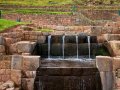
Filtering dikes across periodic runoff paths
In the arid southwestern United States, descendants of the original inhabitants of the region, sometimes continue to build stone dams (check dams) across runoff channels that flow only periodically. These dams, which vary in size and are raised as the soil accumulates behind them, are an excellent means of fertilizing the soil and stabilizing runoff and are used for all kinds of crops.
In the northern highlands of Ethiopia, the construction of such dams is also common in gullies. Combined with vegetation, the placement of check dams reduces the peak flow and volume of runoff, as large sections of the runoff have infiltrated into the sediment deposited behind the dams.

The implementation of many such dams in large areas of the uplands contributes to groundwater recharge and increased base flow in rivers.
The primary objective of this type of work is to slow down the floods in the outlets, while trapping the sediments enriching a small area that it will then be possible to valorize with a highly productive crop (rice, corn, sorghum) even in a deficit year.
In the book Restauration de la productivité des sols tropicaux et méditerranéens Éric Roose et al. report that sorghum yields have increased from an average of 0.6 t/ha in dry conditions on undeveloped slopes, to 1 t/ha on undeveloped lowlands and 1.9 t/ha on developed plots with a filtering dam.
In some situations, these dams allow the storage of a few hundred cubic meters of runoff water until the sediment reaches the top of the structure, which allows for the watering of livestock or the irrigation of a small garden. In any case, these structures have a remarkable effect on gully erosion and groundwater recharge.

- Dimensions d’une et schéma global d’un’ digue filtrante en pierre
Building dikes requires a certain amount of engineering: if the dike crest is not perfectly horizontal or if filtration is too rapid through the large stone dike, runoff can wash away the crest stones or dig a foxhole under the dike that will eventually form a breach and gully. To prevent this, a gravel filter should be constructed in the foundation bowl and between the large stones in the core of the dike. Normally, the retained water drains away in 2-3 days leaving a soggy area upstream of the dike. Sorghum, which traditionally benefits from valley bottoms, sometimes suffers from waterlogging, while there is not enough water to support a full rice cycle.
Retaining obstacles
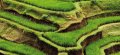
Some developments not only slow down runoff but also concentrate it and force it to infiltrate. This is accomplished by altering the slope profile by raising permanent contour soil benches or by digging ditches.
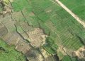
The development of slopes is very common throughout northern Africa and around the Mediterranean basin. Their configurations vary according to slope inclination, soil types, crop species, and local habits.

- Exemples de fossés et gradins aménagés sur pente
The construction of contour dykes on a contour line is quite common. Depending on the environmental conditions of the areas where they are used, the purpose of these dikes is different:
![]() in semi-arid areas, their purpose is to harvest and conserve rainfall.
in semi-arid areas, their purpose is to harvest and conserve rainfall.
![]() In wetlands, on the other hand, their function is to drain off excess runoff.
In wetlands, on the other hand, their function is to drain off excess runoff.
In all cases their common objective is to make conditions more favorable to plant growth and to prevent the loss of water and soil.
Their implementation reduces soil erosion by breaking down long slopes into smaller sections. As runoff velocity decreases, water can more easily infiltrate the soil between the dikes. Nutrient leaching is reduced and more water is available for crops.
Earth bunds and ridges in southern Africa are soil conservation structures that involve the construction of an earth bund along contours by digging a channel and creating a small ridge below. Usually, the earth used to build the dike is taken from above and below the structure. These are often reinforced with a vegetation cover to stabilize the construction. These features are consolidated each year by adding soil to the dike.
These linear barriers can also be vegetated strips which have the advantage, where they can be installed, of being less expensive and less labor intensive. These strips are an easy way to terrace, especially in areas with relatively good rainfall. The spacing of 10 to 30 m between strips depends on the slope of the land. Vegetative strips can also provide fodder for livestock if palatable grass varieties are used.


In Cape Verde, Aloe vera, a fleshy, drought-resistant plant is frequently chosen to establish such barriers to regenerate degraded slopes in the archipelago’s islands. The plants are planted tightly along the contour lines to form effective barriers, which trap eroded sediments and runoff. These living hedges stabilize the soil and increase soil moisture by improving infiltration and soil structure. Soil builds up behind the Aloe strips and the slope is significantly reduced over time. The water table is indirectly recharged. Soil cover increases and evaporation decreases.

- Barrières végétales d’Aloe vera
The implementation of these plant barriers is relatively simple. Contours are marked with a string or water level, and then plants are planted every 30-50 cm, spacing the lines 6-10 m apart, depending on the slope. The technology is used in sub-humid and semi-arid areas, on steep slopes with shallow soils, sparse vegetation and high erosion. These areas are typically farmed by farmers practicing rain-fed subsistence agriculture with maize and beans, which are not usually planted on such slopes.
The image above clearly shows that the installation of vegetation barriers facilitates revegetation and increases fertility between two barriers
On slopes greater than 30%, Cape Verdean farmers combine plant barriers with stone walls 40-50 cm wide, and 80-90 cm high. As the plants stabilize the walls, this combined measure is one of the most effective erosion control measures on the Cape. Aloe vera is well adapted to local biophysical conditions and to the usual land use pattern: it can be combined with all crops and is easily accessible. It is easy to plant and transport, the leaves are not consumed by livestock, it is extremely resistant to water stress and grows in all bioclimatic zones of the island. In addition, Aloe vera is harvested for its many traditional medical uses.

Fanya Juu and Fanya chini of Kenya
One of the most successful contour dyke designs was developed by the Kamba communities of eastern Kenya. According to its construction principle, this design is called Fanya juu, a Swahili expression meaning "throw up" or Fanya chini "throw down".
In the fanya juu system, a stone bank is flanked downstream by a ditch that retains the water, the bank itself retaining the runoff and the soil. Crops, usually cereals, are planted between the banks which are protected from erosion by fruit trees planted just before the ditch. An added benefit of this arrangement is that livestock are generally reluctant to cross these earthen levees followed by a ditch .

- Construction d’un Fanya juu
The fanya juu system stores runoff and sediment; it also recharges the water table. However, it is necessary to maintain the ditches well to avoid clogging, which would lead to the later creation of gullies, and to repair damaged banks regularly.

- Paysage de Fanya juu stabilisés par des graminées
In fanya chini system, the excavated soil, obtained by digging trenches 50-60 cm deep and 60 cm wide, is placed on the lower side of the contour trenches, facing downhill.

- Fanya chini
Fanya juu and fanya chini are common in areas with annual rainfall of 300-600 mm on slopes of 5-25%. They are suitable for all types of relatively permeable soils (e.g., alluvium, red soils, laterites, brown soils, shallow and medium black soils), but do not work well with clay soils or Vertisols that are not permeable.
In fanya juu and fanya chini, the presence of the dikes ensures the formation of micro-basins that concentrate runoff from the land upstream of the dikes. Contour bunds work very well in conjunction with tree planting as a water harvesting technology. Indeed, this system is not only often used to grow annual crops such as Zea mays (maize), Eragrostis tef (teff) and Vicia faba L. (fava beans), but it can also be used for water-demanding crops such as bananas, fruits, and vegetables, which are typically planted where runoff collects (e.g., immediately above or below bunds).
Evaluation of the impact of stone wall cordons of the fanya juu type
Saiz, Gustavo et al. (2016) evaluated the long-term (30-year) impact of Fanya-juu on soil organic matter properties in southeastern Kenya. Compared to sites with conventional agricultural practices, the implementation of fanya juu soil and water conservation structures in erosion-prone landscapes restored soil organic matter levels comparable to those observed in nearby semi-natural ecosystems.
The fanya juu sites stored more than a third more organic matter than sites under conventional agricultural practices. The study also found improved pH, significant differences in soil C/N ratios between soil and water conservation farming practices classified by the presence or absence of trees. The presence of tree or shrub in fanya juu sites had a strong impact on the spatial variability of soil organic matter related properties.
Fanya juu developments and slope developments more generally promote the progressive formation of level terraces.

The leveling of slopes and the development of terraces, can also be intentional, but I will not discuss it here. The usefulness of terraces and the art of making them terraces will be the subject of a separate article.

- Low stone walls in the foothills of the Baliem Valley in West Papua
Published online by
13/04/2022
http://lavierebelle.org/techniques-traditionnelles-i
13/04/2022
http://lavierebelle.org/techniques-traditionnelles-i